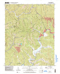
1996 Map of Oceana
USGS Topo · Published 2003About this map
The Oceana Mountains define the high terrain of Wyoming and Logan Counties during the mid-1990s, where the extraction economy of southern West Virginia is evident in the numerous mines and specialized infrastructure like the Tipple Lynco Conveyor. Settlements follow the narrow valley floors, with Lillyhaven and Lillydale situated along the Clear Fork, while Cyclone and Campus line the banks of Huff Creek. Local life is anchored by landmarks such as the Cyclone Ch and Road Branch Sch, reflecting the established rural communities of the era.
Find a feature on this map
59 named features on this map. Tap any name to fly to it.
Don’t see what you’re looking for? This feature index may not catch every label — zoom into the map to look around manually.
Map Details
Editions of this 1996 Oceana Map
This is the sole edition of this map. No revisions or reprints were ever made.
Other maps of this area

1891 · Oceana
USGS Topo · 1:125,000

1893 · Oceana
USGS Topo · 1:125,000

1898 · Oceana
USGS Topo · 1:125,000

1909 · Gilbert
USGS Topo · 1:48,000

1910 · Pineville
USGS Topo · 1:48,000

1910 · Bald Knob
USGS Topo · 1:48,000

1912 · Bald Knob
USGS Topo · 1:62,500

1912 · Gilbert
USGS Topo · 1:62,500

1912 · Pineville
USGS Topo · 1:62,500

1913 · Logan
USGS Topo · 1:62,500