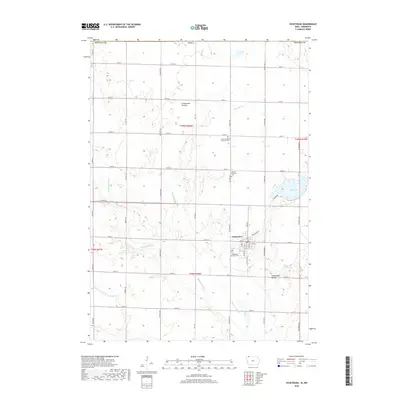
2018 Map of Ocheyedan
USGS Topo · Published 2018About this map
Ocheyedan sits at the heart of this Osceola County landscape, where the agricultural grid is broken by the winding path of the Ocheyedan River and the glacial prominence of the Ocheyedan Mound. This area, part of the larger Coteau des Prairies upland, shows a well-established rural network of section-line roads like Starling Ave and 130th St. The town's grid is detailed down to the residential level, featuring streets such as Main St and Railroad St, while the surrounding countryside is dotted with historical markers of community life. Genealogists will find several burial grounds including Horton Township Cem and Zion Evangelical Lutheran Cem. To the east, the waters of Rush Lake and the Sutton Lake Marsh define the local hydrography, connected by the Rush Lake Outlet that feeds back into the river system.
Find a feature on this map
44 named features on this map. Tap any name to fly to it.
Don’t see what you’re looking for? This feature index may not catch every label — zoom into the map to look around manually.
Map Details
Editions of this 2018 Ocheyedan Map
This is the sole edition of this map. No revisions or reprints were ever made.
Other maps of this area
1954 · Fairmont
USGS Topo · 1:250,000
1958 · Fairmont
USGS Topo · 1:250,000
1960 · Bigelow
USGS Topo · 1:24,000
1960 · Worthington South
USGS Topo · 1:24,000
1960 · Round Lake
USGS Topo · 1:24,000
1970 · May City
USGS Topo · 1:24,000
1970 · Harris
USGS Topo · 1:24,000
1972 · Ocheyedan
USGS Topo · 1:24,000
1972 · Cloverdale
USGS Topo · 1:24,000
1972 · Sibley East
USGS Topo · 1:24,000