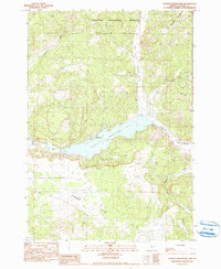
1990 Map of Ochoco Reservoir
USGS Topo · Published 1990About this map
Ochoco Reservoir dominates the central landscape of this 1990 survey, serving as a primary water management feature for the surrounding high desert terrain in Crook County. The engineering of the Ochoco Dam and its adjacent Spillway are clearly documented, along with the recreational infrastructure of Ochoco Lake State Park situated along the northern shore. The map illustrates the transition from the relatively level Combs Flat in the south to the rising elevations of the Ochoco Mountains and the Ochoco National Forest to the north and east.
Find a feature on this map
15 named features on this map. Tap any name to fly to it.
Don’t see what you’re looking for? This feature index may not catch every label — zoom into the map to look around manually.
Map Details
Editions of this 1990 Ochoco Reservoir Map
This is the sole edition of this map. No revisions or reprints were ever made.
Other maps of this area

1946 · Eagle Rock
USGS Topo · 1:62,500

1948 · Eagle Rock
USGS Topo · 1:62,500

1948 · Ochoco Reservoir
USGS Topo · 1:62,500

1950 · Ochoco Reservoir
USGS Topo · 1:62,500

1955 · Bend
USGS Topo · 1:250,000

1957 · Bend
USGS Topo · 1:250,000

1958 · Bend
USGS Topo · 1:250,000

1962 · Prineville
USGS Topo · 1:24,000

1962 · Powell Buttes
USGS Topo · 1:62,500

1962 · Prineville
USGS Topo · 1:62,500