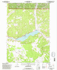
1992 Map of Ochoco Reservoir
USGS Topo · Published 1997About this map
Ochoco Reservoir dominates this central Oregon landscape, serving as a primary water management feature where the high desert meets the southern slopes of the Ochoco Mountains. This 1992 field-checked survey illustrates the complex water system fed by Ochoco Creek, Mill Creek, and Johnson Creek, highlighting the vital role of the Ochoco Spillway in controlling the reservoir's levels. To the south, the expansive plateau of Combs Flat transitions into the drainage of Gravy Gulch, showing the contrast between the flat upland terrain and the dissected creek beds.
Find a feature on this map
29 named features on this map. Tap any name to fly to it.
Don’t see what you’re looking for? This feature index may not catch every label — zoom into the map to look around manually.
Map Details
Editions of this 1992 Ochoco Reservoir Map
This is the sole edition of this map. No revisions or reprints were ever made.
Other maps of this area

1946 · Eagle Rock
USGS Topo · 1:62,500

1948 · Eagle Rock
USGS Topo · 1:62,500

1948 · Ochoco Reservoir
USGS Topo · 1:62,500

1950 · Ochoco Reservoir
USGS Topo · 1:62,500

1955 · Bend
USGS Topo · 1:250,000

1957 · Bend
USGS Topo · 1:250,000

1958 · Bend
USGS Topo · 1:250,000

1962 · Prineville
USGS Topo · 1:24,000

1962 · Powell Buttes
USGS Topo · 1:62,500

1962 · Prineville
USGS Topo · 1:62,500