1991 Map of Oconomowoc
USGS Topo · Published 1991About this map
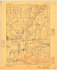
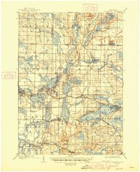
The Horicon Marsh State Wildlife Area dominates the northern reaches of this landscape, marking a transition from the agricultural plains of Dodge Co to the dense lake districts of Waukesha Co. In the early 1990s, the region shows a complex mix of sprawling conservation areas and the westward expansion of the Milwaukee metropolitan area. The glacial heritage of the land is evident in the cluster of lakes such as Lac La Belle and Pewaukee Lake, as well as the prominent elevation at Holy Hill. This era captures the significant rail infrastructure provided by the Chicago & North Western RR and the Soo Line RR, connecting industrial centers like Watertown and Waukesha. Cultural and educational landmarks, including Carroll College and the ancient site at Aztalan State Park, reflect a long history of human occupation along the Rock River.
Find a feature on this map
221 named features on this map. Tap any name to fly to it.
Don’t see what you’re looking for? This feature index may not catch every label — zoom into the map to look around manually.
Map Details
Editions of this 1991 Oconomowoc Map
This is the sole edition of this map. No revisions or reprints were ever made.
Historical Maps of Milwaukee Through Time
4 maps found