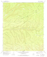
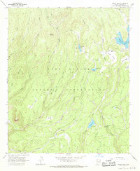
1978 Map of Odart Mtn
USGS Topo · Published 1978About this map
The Fort Apache Indian Reservation defines the high-altitude landscape of this 1970s survey, characterized by a complex network of canyons and high summits. Rising above the terrain, Odart Mtn serves as a prominent landmark with its established Lookout Tower, overseeing a region of deep drainage systems. Water is a central feature of the topography, from the winding path of Big Bonito Creek in the north to Tonto Creek and Cienega Creek further south. The map documents an area primarily accessed via a network of Jeep Trails, illustrating the specialized transportation required for such a remote territory. Notable natural landmarks include the broad Lofer Bench and Lion Mountain, while smaller features like Maverick Lake and several Gravel Pit sites indicate localized resource extraction and water management within the reservation boundaries.
Find a feature on this map
21 named features on this map. Tap any name to fly to it.
Don’t see what you’re looking for? This feature index may not catch every label — zoom into the map to look around manually.
Map Details
Editions of this 1978 Odart Mtn Map
This is the sole edition of this map. No revisions or reprints were ever made.
Other maps of this area

1954 · Clifton
USGS Topo · 1:250,000

1957 · Clifton
USGS Topo · 1:250,000

1958 · Clifton
USGS Topo · 1:250,000

1962 · Clifton
USGS Topo · 1:250,000

1967 · Marshall Butte
USGS Topo · 1:24,000

1967 · Freezeout Mountain
USGS Topo · 1:24,000
1967 · Corn Creek Plateau
USGS Topo · 1:24,000
1967 · Maverick SW
USGS Topo · 1:24,000
1967 · West Poker Mtn.
USGS Topo · 1:24,000
1967 · Bonito Rock
USGS Topo · 1:24,000