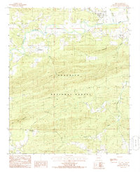
1985 Map of Oden
USGS Topo · Published 1986About this map
The Ouachita River meanders through this portion of Montgomery County, defining a valley surrounded by the high ridges of the Ouachita National Forest. This mid-1980s provisional survey shows the settlement of Oden positioned near the confluence of Lick Branch and the main river channel, serving as a local hub for the surrounding rural communities. Further south and west, the map records smaller locales such as Huddleston, Gaston, and Union Hill, the latter of which is anchored by the Union Hill Ch and a nearby Cem.
Find a feature on this map
24 named features on this map. Tap any name to fly to it.
Don’t see what you’re looking for? This feature index may not catch every label — zoom into the map to look around manually.
Map Details
Editions of this 1985 Oden Map
This is the sole edition of this map. No revisions or reprints were ever made.
Other maps of this area

1890 · Mount Ida
USGS Topo · 1:125,000

1906 · Caddo Gap
USGS Topo · 1:125,000

1936 · Athens
USGS Topo · 1:48,000

1936 · Glenwood
USGS Topo · 1:48,000

1942 · Glenwood
USGS Topo · 1:62,500

1942 · Athens
USGS Topo · 1:62,500

1949 · Glenwood
USGS Topo · 1:62,500

1955 · Little Rock
USGS Topo · 1:250,000

1956 · Little Rock
USGS Topo · 1:250,000

1959 · Oden
USGS Topo · 1:62,500