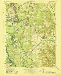
1946 Map of Odenton
USGS Topo · Published 1946About this map
Fort George G Meade Military Reservation dominates the western landscape of this 1946 survey, showing a massive complex of ranges and utility structures just after the war. The military presence is marked by technical infrastructure like the USC&GS Heating Plant Stack 1942 and several laundry tanks. Beyond the reservation boundary, the rural character of Anne Arundel County persists through small settlements and family-named locales like Sappington, Gambrills, and Millersville clustered along the Pennsylvania Railroad and the Robert Crain Highway. A notable concentration of community centers is evident, from the U. S. Naval Academy Dairy to historic spiritual sites such as St Stephens Church and Waugh Chapel. The Patuxent River and Little Patuxent River provide natural boundaries, while the unique Forest and Stream Animal Cemetery appears in the north, offering a rare look at specialized land use in the mid-century.
Find a feature on this map
52 named features on this map. Tap any name to fly to it.
Don’t see what you’re looking for? This feature index may not catch every label — zoom into the map to look around manually.
Map Details
Editions of this 1946 Odenton Map
This is the sole edition of this map. No revisions or reprints were ever made.
Other maps of this area

1892 · Laurel
USGS Topo · 1:62,500

1892 · Owensville
USGS Topo · 1:62,500

1894 · Laurel
USGS Topo · 1:62,500

1894 · Relay
USGS Topo · 1:62,500

1895 · Owensville
USGS Topo · 1:62,500

1897 · Laurel
USGS Topo · 1:62,500

1899 · Patuxent
USGS Topo · 1:125,000

1900 · Washington
USGS Topo · 1:62,500

1905 · Owensville
USGS Topo · 1:62,500

1906 · Patuxent
USGS Topo · 1:125,000