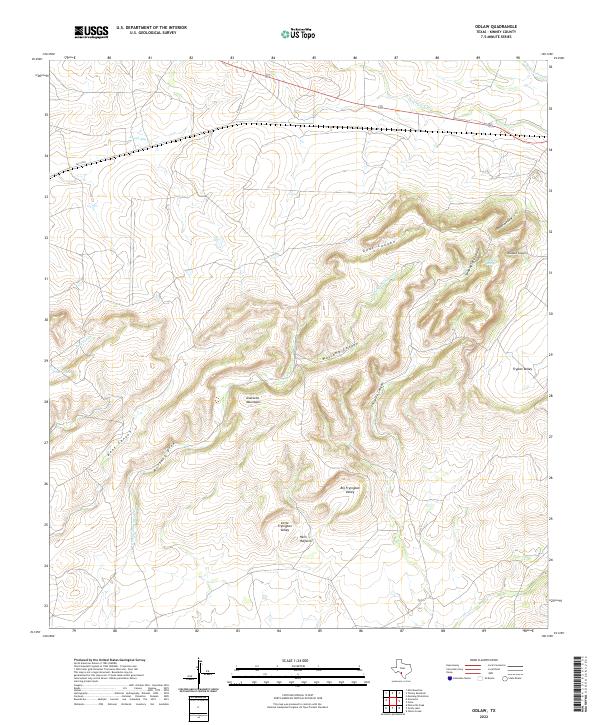
2022 Map of Odlaw
USGS Topo · Published 2022About this map
The Anacacho Mountains anchor this southern Texas landscape, where complex drainage patterns define the topography between the Edwards Plateau and the Rio Grande Plain. This 2022 survey details a network of deeply etched canyons and draws, including Mustang Canyon, Beef Canyon, and Chiliptin Canyon, which direct seasonal runoff toward the south. The transition from high ridges to low basins is most evident in the distinct geological depressions of Big Fryingpan Valley and Little Fryingpan Valley, alongside the evocative landmark of Hells Halfacre. Human presence in this arid region is largely defined by water management for ranching, evidenced by Tonto Tank and the presence of Sleeping Spring. The northern portion of the quadrangle is bisected by FM 1572 E, providing the primary transit route through an otherwise sparsely populated terrain of rimrock and seasonal creeks like Muela Cr.
Find a feature on this map
22 named features on this map. Tap any name to fly to it.
Don’t see what you’re looking for? This feature index may not catch every label — zoom into the map to look around manually.
Map Details
Editions of this 2022 Odlaw Map
This is the sole edition of this map. No revisions or reprints were ever made.
Other maps of this area

1896 · Brackett
USGS Topo · 1:125,000

1897 · Brackett
USGS Topo · 1:125,000

1938 · Turkey Mountain
USGS Topo · 1:48,000

1943 · Turkey Mountain
USGS Topo · 1:62,500

1944 · Spofford
USGS Topo · 1:62,500

1944 · Brackettville
USGS Topo · 1:62,500

1949 · Cline
USGS Topo · 1:62,500

1958 · Del Rio
USGS Topo · 1:250,000

1964 · Del Rio
USGS Topo · 1:250,000
1974 · Elm Mountain
USGS Topo · 1:24,000