1982 Map of Ogden
USGS Topo · Published 1982About this map
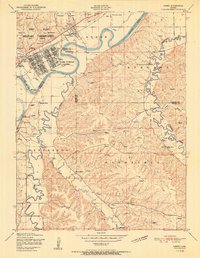
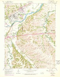
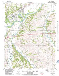
Fort Riley Military Reservation dominates the northwestern portion of this landscape, where military infrastructure meets the natural confluence of the Kansas River and Clarks Creek. The expansive facilities of Camp Funston are clearly visible, featuring a structured grid of buildings and the Funston Monument overlooking the river valley. The Union Pacific railroad tracks provide the primary industrial corridor, skirting the southern edge of the town of Ogden. Outside the military grounds, the topography shifts into the high ridges of Ashland and Wingfield, punctuated by rural landmarks such as Berry Sch and St Josephs Ch. Genealogists will find several burial grounds noted, including St Patricks Cem and Humboldt Cem, which serve as markers for the area's long-established pioneer and military families.
Find a feature on this map
33 named features on this map. Tap any name to fly to it.
Don’t see what you’re looking for? This feature index may not catch every label — zoom into the map to look around manually.
Map Details
Editions of this 1982 Ogden Map
This is the sole edition of this map. No revisions or reprints were ever made.
Historical Maps of Manhattan Through Time
8 maps found