
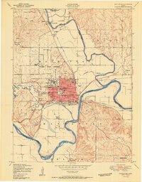
1950 Map of Manhattan
USGS Topo · Published 1950About this map
Manhattan sits at the confluence of the Big Blue River and the Kansas River, serving as a regional hub of education and transport in the post-war era. The campus of Kansas State College dominates the northern portion of the city, with Memorial Stadium and nearby residential streets like Anderson Avenue and Poyntz Avenue showing the town's mid-century expansion. The landscape is deeply tied to the railroads, with the Union Pacific and Chicago Rock Island and Pacific lines tracing the riverbanks and supporting local industry, such as the Cattle loading station near Rockford.
Find a feature on this map
49 named features on this map. Tap any name to fly to it.
Don’t see what you’re looking for? This feature index may not catch every label — zoom into the map to look around manually.
Map Details
Editions of this 1950 Manhattan Map
2 editions found
Other maps of this area

1886 · Junction City
USGS Topo · 1:125,000

1889 · Wamego
USGS Topo · 1:125,000

1889 · Junction City
USGS Topo · 1:125,000

1894 · Junction City
USGS Topo · 1:125,000

1894 · Wamego
USGS Topo · 1:125,000

1947 · Manhattan
USGS Topo · 1:62,500

1950 · Keats
USGS Topo · 1:24,000

1951 · Swede Creek
USGS Topo · 1:24,000

1951 · Ogden
USGS Topo · 1:24,000

1953 · St George
USGS Topo · 1:24,000