
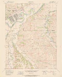
1951 Map of Ogden
USGS Topo · Published 1951About this map
Camp Funston and the surrounding Fort Riley Military Reservation anchor this mid-century survey of the landscape where the Kansas River meets its tributaries. The military infrastructure is deeply integrated with the natural terrain, featuring a swimming pool, sewage disposal, and grain elevator near the Union Pacific tracks. Outside the post, the rural character of the Ashland and Wingfield areas is defined by a dense network of country schools, such as Walnut Grove School and Enterprise School, and family-oriented landmarks. The complex boundary lines between Riley, Geary, and Jefferson counties traverse a landscape of high bluffs like Campbell Hill and Sumner Hill, while smaller waterways like McDowell Creek and Humboldt Creek carve through the agricultural uplands. This map documents a period of transition as post-war military expansion met established prairie settlements and traditional cemeteries, including St Patricks and Fairview Cemetery.
Find a feature on this map
37 named features on this map. Tap any name to fly to it.
Don’t see what you’re looking for? This feature index may not catch every label — zoom into the map to look around manually.
Map Details
Editions of this 1951 Ogden Map
2 editions found
Other maps of this area

1886 · Junction City
USGS Topo · 1:125,000

1889 · Junction City
USGS Topo · 1:125,000

1889 · Parkerville
USGS Topo · 1:125,000

1894 · Junction City
USGS Topo · 1:125,000

1894 · Parkerville
USGS Topo · 1:125,000

1947 · Manhattan
USGS Topo · 1:62,500

1947 · Fort Riley
USGS Topo · 1:62,500

1950 · Keats
USGS Topo · 1:24,000

1950 · Manhattan
USGS Topo · 1:24,000

1950 · Junction City
USGS Topo · 1:24,000