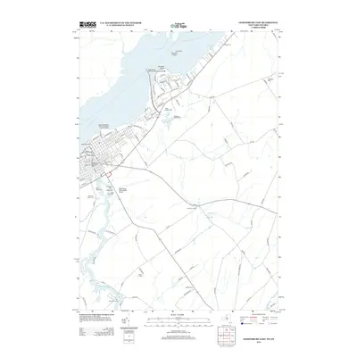
2013 Map of Ogdensburg East
USGS Topo · Published 2013About this map
The Saint Lawrence River serves as a dominant focal point for this borderlands region, where the Ogdensburg- Prescott International Bridge connects New York to Canada. The urban landscape of eastern Ogdensburg is characterized by its heavy concentration of community infrastructure and burial grounds, including the large Riverside Cem, Saint Marys Cem, and Notre Dame Cem. Near the riverfront, the Ogdensburg Bridge and Port Authority Marine Terminal and Ogdensburg City Water Works indicate the city's industrial and logistical reliance on the waterway.
Find a feature on this map
103 named features on this map. Tap any name to fly to it.
Don’t see what you’re looking for? This feature index may not catch every label — zoom into the map to look around manually.
Map Details
Editions of this 2013 Ogdensburg East Map
This is the sole edition of this map. No revisions or reprints were ever made.
Other maps of this area

1904 · Lisbon
USGS Topo · 1:48,000

1904 · Ogdensburg
USGS Topo · 1:62,500

1905 · Ogdensburg
USGS Topo · 1:62,500

1906 · Brier Hill
USGS Topo · 1:62,500

1906 · Red Mills
USGS Topo · 1:62,500

1943 · Ogdensburg East
USGS Topo · 1:31,680

1943 · Rensselaer Falls
USGS Topo · 1:31,680

1943 · Lisbon
USGS Topo · 1:31,680
1943 · Red Mills
USGS Topo · 1:31,680
1943 · Sparrowhawk Point
USGS Topo · 1:31,680