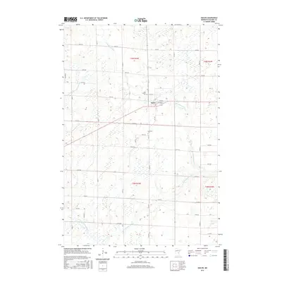
2016 Map of Ogilvie
USGS Topo · Published 2016About this map
Ogilvie stands as the central settlement in this portion of Kanabec County, surrounded by a landscape defined by the drainage of the Groundhouse River. The river and its tributary, the S Fork Groundhouse River, meander through a grid of rural roads including Co Rd 57 and Co Rd 10. This 2016 survey illustrates the persistent agricultural and cemetery layout of the region, specifically marking Saint Kathryn Cem and Graceland Cem near the town center. The map reflects a modern rural Minnesota character, where family farms are accessed via a methodical network of numbered avenues and named streets such as Cable ST and Garden ST. The topography reveals the low-lying nature of the river valley, with elevation contours tracing the subtle rises and falls of the surrounding fields and wetlands.
Find a feature on this map
40 named features on this map. Tap any name to fly to it.
Don’t see what you’re looking for? This feature index may not catch every label — zoom into the map to look around manually.
Map Details
Editions of this 2016 Ogilvie Map
This is the sole edition of this map. No revisions or reprints were ever made.
Other maps of this area
1953 · Stillwater
USGS Topo · 1:250,000
1955 · Stillwater
USGS Topo · 1:250,000
1958 · Stillwater
USGS Topo · 1:250,000
1961 · Springvale
USGS Topo · 1:24,000
1961 · Dalbo
USGS Topo · 1:24,000
1961 · Dalbo
USGS Topo · 1:62,500
1965 · Stillwater
USGS Topo · 1:250,000
1968 · Milaca NE
USGS Topo · 1:24,000
1968 · Ann Lake
USGS Topo · 1:24,000
1968 · Mora North
USGS Topo · 1:24,000