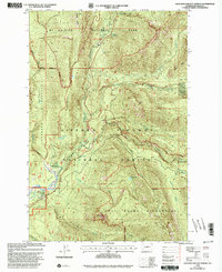
1998 Map of Ohanapecosh Hot Springs
USGS Topo · Published 2003About this map
Ohanapecosh Hot Springs serves as a central landmark in this high-elevation landscape where the Mt Rainier National Park boundary meets the Gifford Pinchot National Forest. The geography is defined by deep river drainages and sharp ascents, including the Cowlitz Divide and Backbone Ridge. Public recreation and infrastructure are well-documented here, from the Ohanapecosh Campground and a local Ranger Station to the La Wis Wis Campground further south.
Find a feature on this map
37 named features on this map. Tap any name to fly to it.
Don’t see what you’re looking for? This feature index may not catch every label — zoom into the map to look around manually.
Map Details
Editions of this 1998 Ohanapecosh Hot Springs Map
This is the sole edition of this map. No revisions or reprints were ever made.
Other maps of this area

1902 · Mount Aix
USGS Topo · 1:125,000

1904 · Mt Aix
USGS Topo · 1:125,000

1924 · Mt Rainier
USGS Topo · 1:96,000

1928 · Mt Rainier
USGS Topo · 1:125,000

1950 · Yakima
USGS Topo · 1:250,000

1958 · Yakima
USGS Topo · 1:250,000

1961 · Yakima
USGS Topo · 1:250,000

1962 · Bumping Lake
USGS Topo · 1:62,500

1962 · White Pass
USGS Topo · 1:62,500

1962 · Packwood
USGS Topo · 1:62,500