1978 Map of Oildale
USGS Topo · Published 1981About this map
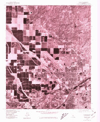
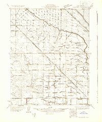
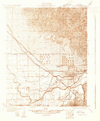
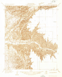
Bakersfield and its northern industrial and agricultural fringes come into sharp focus in this late-1970s orthophotograph. The settlement of Oildale dominates the center-right of the sheet, revealing the high-density residential grid and large-scale industrial infrastructure, including numerous storage tanks and refinery facilities, that defined the area's development. To the west, the landscape shifts abruptly to the geometric precision of Central Valley agriculture, where large rectangular plots are bisected by irrigation canals and the diagonal path of the railroad through Saco. This visual record, produced in cooperation with the Soil Conservation Service, documents the precise boundary between the expanding urban footprint and the managed farmland of Fruitvale and Greenacres before the continued suburbanization of Kern County. It provides a technical perspective on land use, showing the intricate relationship between oil production, transportation corridors, and the region's agricultural foundations.
Find a feature on this map
5 named features on this map. Tap any name to fly to it.
Don’t see what you’re looking for? This feature index may not catch every label — zoom into the map to look around manually.
Map Details
Editions of this 1978 Oildale Map
This is the sole edition of this map. No revisions or reprints were ever made.
Other maps of this area

1906 · Bakersfield
USGS Topo · 1:62,500

1910 · Buena Vista Lake
USGS Topo · 1:125,000

1912 · Buena Vista Lake
USGS Topo · 1:125,000

1914 · Caliente
USGS Topo · 1:125,000
1929 · Stevens
USGS Topo · 1:31,680
1929 · Fairfax School
USGS Topo · 1:31,680
1930 · Famoso
USGS Topo · 1:31,680
1930 · Rosedale
USGS Topo · 1:31,680
1930 · Oildale
USGS Topo · 1:31,680
1932 · North of Oildale
USGS Topo · 1:31,680