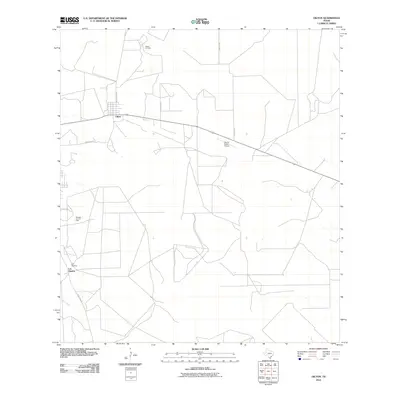
2010 Map of Oilton
USGS Topo · Published 2010About this map
Oilton and the historic settlement of Los Ojuelos anchor this South Texas landscape during a period of ongoing petroleum extraction. The area's industrial character is defined by the Killam Oil Field in the north and the Mirando City Oil Field to the west, reflecting the deep-rooted energy economy of Webb County. The terrain is marked by a sparse network of roads, including Welhousen Rd and Carolina Rd, which connect remote ranching operations and oil infrastructure. Modern aviation is represented by the Van Es Ranch Airport, while the natural drainage of Ryo Creek cuts across the southwestern corner of the quadrangle. This survey illustrates the specialized land use of the region, where wide-scale oil production and traditional ranching coexist along corridors like Magnolia Rd and Ranch Rd 649.
Find a feature on this map
11 named features on this map. Tap any name to fly to it.
Don’t see what you’re looking for? This feature index may not catch every label — zoom into the map to look around manually.
Map Details
Editions of this 2010 Oilton Map
This is the sole edition of this map. No revisions or reprints were ever made.
Other maps of this area

1937 · Aguilete Creek
USGS Topo · 1:62,500

1939 · Bruni
USGS Topo · 1:62,500

1940 · Aguilares
USGS Topo · 1:62,500

1956 · Laredo
USGS Topo · 1:250,000
1968 · Mills Bennett SW
USGS Topo · 1:24,000

1968 · San Pablo
USGS Topo · 1:24,000

1972 · Albercas Ranch
USGS Topo · 1:24,000

1972 · Bruni SE
USGS Topo · 1:24,000
1972 · Bruni
USGS Topo · 1:24,000
1972 · Oilton
USGS Topo · 1:24,000