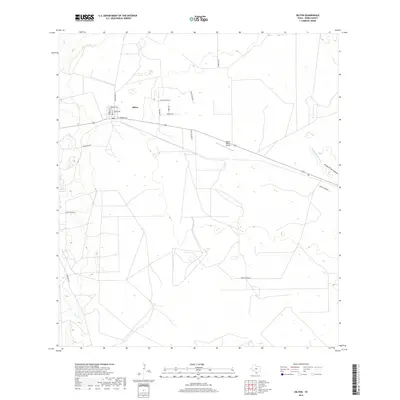
2019 Map of Oilton
USGS Topo · Published 2019About this map
Oilton serves as the central hub of this South Texas landscape, where a grid of residential streets like Ramona Ave and E Laredo Ave meets the open ranching country of Webb County. The presence of a Po and the Van Es Ranch Airport indicates a pocket of infrastructure supporting the surrounding rural economy. Beyond the town limits, the terrain is defined by ephemeral waterways such as Ryo Cr and the larger Arroyo de los Angeles, which carve through a network of ranch roads including Welhousen Rd and Magnolia Rd. The map illustrates a high degree of land partitioning, with numerous numbered ranch roads like Ranch Rd 8034A and Ranch Rd 8054B providing access to the interior brushland and private holdings typical of this region.
Find a feature on this map
23 named features on this map. Tap any name to fly to it.
Don’t see what you’re looking for? This feature index may not catch every label — zoom into the map to look around manually.
Map Details
Editions of this 2019 Oilton Map
This is the sole edition of this map. No revisions or reprints were ever made.
Other maps of this area
1937 · Aguilete Creek
USGS Topo · 1:62,500
1939 · Bruni
USGS Topo · 1:62,500
1940 · Aguilares
USGS Topo · 1:62,500
1956 · Laredo
USGS Topo · 1:250,000
1968 · Mills Bennett SW
USGS Topo · 1:24,000
1968 · San Pablo
USGS Topo · 1:24,000
1972 · Albercas Ranch
USGS Topo · 1:24,000
1972 · Bruni SE
USGS Topo · 1:24,000
1972 · Bruni
USGS Topo · 1:24,000
1972 · Oilton
USGS Topo · 1:24,000