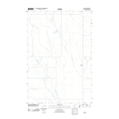
2011 Map of Oka
USGS Topo · Published 2011About this map
Oka serves as the primary named point of reference in this sparsely populated section of Wheatland County. The landscape is defined by its intermittent drainage patterns, with Roberts Creek and Antelope Creek winding through a system of managed water resources. Water management is a central feature of this ranching and grazing territory, evidenced by the Lode Reservoir and the Grazing Antelope Dam. Local infrastructure is focused on utility and accessibility, primarily through roads such as 191 North 14th W and 12E 101N Rd. This map reflects the vast, open character of central Montana, where water bodies like Alkali Creek and artificial reservoirs are critical landmarks in a region dominated by wide-open spaces and rural land use.
Find a feature on this map
8 named features on this map. Tap any name to fly to it.
Don’t see what you’re looking for? This feature index may not catch every label — zoom into the map to look around manually.
Map Details
Editions of this 2011 Oka Map
This is the sole edition of this map. No revisions or reprints were ever made.
Other maps of this area

1889 · Big Snowy Mountain
USGS Topo · 1:250,000

1893 · Big Snowy Mountain
USGS Topo · 1:250,000

1954 · Roundup
USGS Topo · 1:250,000

1958 · Roundup
USGS Topo · 1:250,000
1986 · Oka
USGS Topo · 1:24,000
1986 · Mead Creek
USGS Topo · 1:24,000
1986 · Judith Gap
USGS Topo · 1:24,000
1986 · Hopley Creek North
USGS Topo · 1:24,000
1986 · Oxford
USGS Topo · 1:24,000
1986 · Harlowton
USGS Topo · 1:24,000