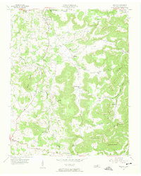
1955 Map of Okalona
USGS Topo · Published 1956About this map
The Roaring River winds through the heart of this Overton County landscape, a terrain defined by deep coves and rising ridges typical of the Cumberland Plateau's western edge. Small settlements such as Okalona and Oak Grove serve as local hubs, connected by a network of rural roads that weave between Maxwell Mountain and Harris Mountain. The area exhibits a dense distribution of social landmarks, from the Bethlehem Ch and Union Hill Ch to the Pleasant Valley Sch, reflecting a well-established community of small family farms.
Find a feature on this map
40 named features on this map. Tap any name to fly to it.
Don’t see what you’re looking for? This feature index may not catch every label — zoom into the map to look around manually.
Map Details
Editions of this 1955 Okalona Map
3 editions found
Other maps of this area

1897 · Standingstone
USGS Topo · 1:125,000

1898 · Standingstone
USGS Topo · 1:125,000

1943 · Cookeville
USGS Topo · 1:100,000

1944 · Cookeville
USGS Topo · 1:100,000

1944 · Livingston
USGS Topo · 1:24,000

1946 · Obey City
USGS Topo · 1:24,000
1950 · Obey City
USGS Topo · 1:24,000

1951 · Windle
USGS Topo · 1:24,000

1953 · Cookeville East
USGS Topo · 1:24,000

1954 · Crawford
USGS Topo · 1:24,000