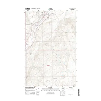
2014 Map of Okanogan
USGS Topo · Published 2014About this map
Okanogan sits along the banks of the Okanogan River, serving as a central hub in north-central Washington as documented in this 2014 survey. The town's layout is defined by the river's path, with Woody Island situated just south of the main settlement and the Okanogan Legion Airport positioned on the plateau above the valley floor. The geography shifts from the river bottom to the high country of the Okanogan Highlands, where the land is marked by prominent landmarks like Jackass Butte.
Find a feature on this map
50 named features on this map. Tap any name to fly to it.
Don’t see what you’re looking for? This feature index may not catch every label — zoom into the map to look around manually.
Map Details
Editions of this 2014 Okanogan Map
This is the sole edition of this map. No revisions or reprints were ever made.
Other maps of this area

1905 · Okanogan
USGS Topo · 1:125,000

1950 · Boot Mtn
USGS Topo · 1:62,500

1953 · Omak Lake
USGS Topo · 1:62,500

1954 · Okanogan
USGS Topo · 1:250,000

1957 · Okanogan
USGS Topo · 1:62,500

1957 · Bridgeport
USGS Topo · 1:62,500

1958 · Okanogan
USGS Topo · 1:250,000

1980 · Okanogan
USGS Topo · 1:24,000
1980 · Omak
USGS Topo · 1:24,000
1980 · Joe Lake
USGS Topo · 1:24,000