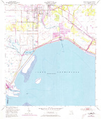
1952 Map of Okeechobee
USGS Topo · Published 1973About this map
Okeechobee serves as the focal point of this mid-century survey, situated at the northern edge of the massive Lake Okeechobee basin. The town's grid is well-defined around Flagler Park, with the Seaboard Coast Line railroad cutting through the landscape to the settlement of Sherman. The relationship between the land and water is clearly illustrated by the extensive Levee system that borders the lake, protecting the town and its infrastructure, including a prominent Waterworks and Hospital.
Find a feature on this map
20 named features on this map. Tap any name to fly to it.
Don’t see what you’re looking for? This feature index may not catch every label — zoom into the map to look around manually.
Map Details
Editions of this 1952 Okeechobee Map
4 editions found
Other maps of this area

1952 · Okeechobee NW
USGS Topo · 1:24,000

1952 · Okeechobee
USGS Topo · 1:24,000

1953 · Okeechobee 4 SW
USGS Topo · 1:24,000

1953 · Okeechobee SW
USGS Topo · 1:24,000

1953 · Okeechobee 4 NW
USGS Topo · 1:24,000

1953 · Taylor Creek SW
USGS Topo · 1:24,000

1953 · Okeechobee 1 SW
USGS Topo · 1:24,000

1953 · Taylor Creek SE
USGS Topo · 1:24,000

1956 · Fort Pierce
USGS Topo · 1:250,000

1958 · Fort Pierce
USGS Topo · 1:250,000