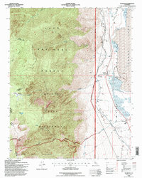
1994 Map of Olancha
USGS Topo · Published 1997About this map
Owens Valley landscape dynamics are on full display in this mid-1990s study, where the eastern slopes of the Sierra Nevada meet the edge of Owens Lake. The transition from the high-altitude Golden Trout Wilderness and South Sierra Wilderness down to the valley floor is defined by steep drainages like Olancha Creek and Cartago Creek. At the base of these mountains, the small settlements of Olancha and Cartago sit as gateways to the eastern Sierra, while the Los Angeles Aqueduct and Diversion Dikes reflect the significant water management infrastructure that has shaped this region’s environmental and social history. The inclusion of an Old Railroad Grade and scattered Ruins near Cartago provides tangible evidence of the transport and industrial history that once thrived along the lake's former shoreline.
Find a feature on this map
34 named features on this map. Tap any name to fly to it.
Don’t see what you’re looking for? This feature index may not catch every label — zoom into the map to look around manually.
Map Details
Editions of this 1994 Olancha Map
This is the sole edition of this map. No revisions or reprints were ever made.
Other maps of this area

1905 · Olancha
USGS Topo · 1:125,000

1907 · Olancha
USGS Topo · 1:125,000

1908 · Ballarat
USGS Topo · 1:250,000

1913 · Ballarat
USGS Topo · 1:250,000

1948 · Death Valley
USGS Topo · 1:250,000

1948 · Fresno
USGS Topo · 1:250,000

1951 · Keeler
USGS Topo · 1:62,500

1951 · Haiwee Reservoir
USGS Topo · 1:62,500

1954 · Death Valley
USGS Topo · 1:250,000

1955 · Fresno
USGS Topo · 1:250,000