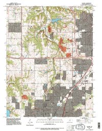
1991 Map of Olathe
USGS Topo · Published 1995About this map
The expanding suburbs of Johnson County meet the established institutional and natural landscapes of Olathe and Lenexa in this 1991 revision. The map documents the city's growth along Santa Fe St, while preserving local landmarks such as the State School For The Deaf and the County Farm. To the north, the recreational character of the county is evident in the sprawling Shawnee Mission County Park, which centers on Shawnee Mission Lake. Smaller, older settlements like Monticello and Craig appear as the suburban grid begins to surround them. The terrain is defined by the drainage of Cedar Creek and Indian Creek, with the industrial footprint of a Pit and Sewage Disposal plant marking the edge of the urbanized area.
Find a feature on this map
32 named features on this map. Tap any name to fly to it.
Don’t see what you’re looking for? This feature index may not catch every label — zoom into the map to look around manually.
Map Details
Editions of this 1991 Olathe Map
This is the sole edition of this map. No revisions or reprints were ever made.
Other maps of this area

1887 · Olathe
USGS Topo · 1:125,000

1890 · Kansas City
USGS Topo · 1:125,000

1893 · Olathe
USGS Topo · 1:125,000

1894 · Kansas City
USGS Topo · 1:125,000

1934 · Bonner Springs
USGS Topo · 1:48,000

1934 · Shawnee
USGS Topo · 1:24,000

1934 · Edwardsville
USGS Topo · 1:24,000

1935 · Olathe
USGS Topo · 1:24,000

1935 · Lenexa
USGS Topo · 1:24,000

1940 · Bonner Springs
USGS Topo · 1:62,500