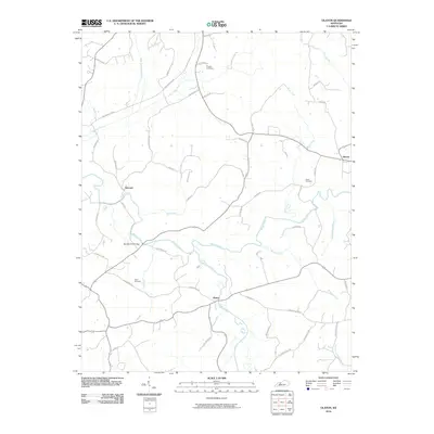
2010 Map of Olaton
USGS Topo · Published 2010About this map
Rough River snakes across this portion of Ohio County, Kentucky, defining the local geography alongside tributaries like Caney Creek and Huff Creek. Small rural settlements such as Olaton, Narrows, and Shreve are connected by a network of country roads, several of which bear the names of local families. A notable legacy of transportation is visible in Railroad Bed Rd, which preserves the path of a former rail line through the hills. For family historians, the landscape is punctuated by ancestral sites including Axton Cemetery, Grant Cemetery, and Haynes Cemetery. The presence of Barretts Ford Bridge across the river highlights a historic crossing point in a region where local travel was long shaped by the water's course and the winding valley floor.
Find a feature on this map
54 named features on this map. Tap any name to fly to it.
Don’t see what you’re looking for? This feature index may not catch every label — zoom into the map to look around manually.
Map Details
Editions of this 2010 Olaton Map
This is the sole edition of this map. No revisions or reprints were ever made.
Other maps of this area

1907 · Whitesville
USGS Topo · 1:62,500

1909 · Whitesville
USGS Topo · 1:62,500

1909 · Hartford
USGS Topo · 1:62,500

1925 · Spring Lick
USGS Topo · 1:62,500

1932 · Fordsville
USGS Topo · 1:62,500

1953 · Dundee
USGS Topo · 1:24,000

1953 · Whitesville
USGS Topo · 1:24,000

1953 · Falls Of Rough
USGS Topo · 1:24,000
1953 · Glen Dean
USGS Topo · 1:24,000
1953 · Fordsville
USGS Topo · 1:24,000