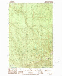
1986 Map of Old Baldy Mtn.
USGS Topo · Published 1987About this map
Upper Fairfax sits at the southwestern edge of this 1980s landscape, positioned near the Carbon River as it flows along the boundary of Mt Ranier National Park. Much of the quadrangle is defined by the heavy timber and drainage systems of the Snoqualmie National Forest, where resource extraction and industrial activity are evidenced by a Mine Tunnel near the center of the sheet and several Borrow Pit locations. High peaks such as Old Baldy Mtn and Burnt Mountain dominate the southern topography, while The Three Sisters rise to the northeast.
Find a feature on this map
22 named features on this map. Tap any name to fly to it.
Don’t see what you’re looking for? This feature index may not catch every label — zoom into the map to look around manually.
Map Details
Editions of this 1986 Old Baldy Mtn. Map
This is the sole edition of this map. No revisions or reprints were ever made.
Other maps of this area

1897 · Tacoma
USGS Topo · 1:125,000

1900 · Tacoma
USGS Topo · 1:125,000

1913 · Cedar Lake
USGS Topo · 1:125,000

1924 · Mt Rainier
USGS Topo · 1:96,000

1928 · Mt Rainier
USGS Topo · 1:125,000

1937 · Eatonville
USGS Topo · 1:125,000

1942 · Lake Tapps
USGS Topo · 1:62,500

1944 · Lake Tapps
USGS Topo · 1:62,500

1950 · Yakima
USGS Topo · 1:250,000

1953 · Hoquiam
USGS Topo · 1:250,000