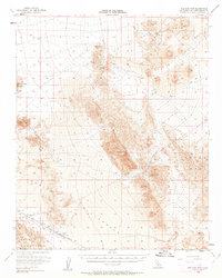
1956 Map of Old Dad Mountain
USGS Topo · Published 1963About this map
Old Dad Mtn and the surrounding Mojave landscape define this 1956 survey, characterized by extreme topography ranging from the towering Kelso Dunes to the vast Playa Ground. The desert floor is marked by the Union Pacific line, which services the small stop at Sands in the southwestern corner. This era of exploration and extraction is evident in the cluster of remote workings found in the highlands, including the Paymaster Mine, Oro Fino Mine, and Rainy Day Mine. These sites, connected by a network of Jeep Trails, represent the mid-century mining interest in San Bernardino County's interior ranges. Water sources are scarce but critical, noted at Indian Spring and Indian Creek, while the northwestern edge of the map touches the expansive Soda Lake. The presence of massive Lava fields and the Bristol Mountains illustrates a terrain where industry and geology are inextricably linked.
Find a feature on this map
21 named features on this map. Tap any name to fly to it.
Don’t see what you’re looking for? This feature index may not catch every label — zoom into the map to look around manually.
Map Details
Editions of this 1956 Old Dad Mountain Map
4 editions found
Other maps of this area

1910 · Ivanpah
USGS Topo · 1:250,000

1912 · Ivanpah
USGS Topo · 1:250,000

1933 · Avawatz Mountains
USGS Topo · 1:250,000

1942 · Ivanpah
USGS Topo · 1:250,000

1942 · Amboy
USGS Topo · 1:250,000

1943 · Amboy
USGS Topo · 1:250,000

1947 · Trona
USGS Topo · 1:250,000

1947 · Kingman
USGS Topo · 1:250,000

1948 · Kingman
USGS Topo · 1:250,000

1948 · Trona
USGS Topo · 1:250,000