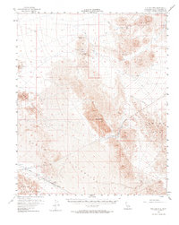
1956 Map of Old Dad Mountain
USGS Topo · Published 1974About this map
Mining operations and arid mountain ranges dominate this mid-century survey of the Mojave Desert. The landscape is defined by the towering Old Dad Mtn and the sprawling expanse of the Devils Playground, where water sources like Indian Spring and Willow Wash were critical for survival. For the local historian or prospector, the map identifies several early industrial sites, including the Paymaster Mine, Oro Fino Mine, and Brannigan Mine located near Seventeenmile Point. Transportation across this unforgiving terrain is marked by the Union Pacific railroad line, which skirts the southern edge of the desert through Sands. To the west, the arid basin of Soda Lake sits between the Cow Hole Mountains and the Bristol Mountains, illustrating a period when remote mineral extraction and rail transport were the primary human activities in this part of San Bernardino County.
Find a feature on this map
23 named features on this map. Tap any name to fly to it.
Don’t see what you’re looking for? This feature index may not catch every label — zoom into the map to look around manually.
Map Details
Editions of this 1956 Old Dad Mountain Map
4 editions found
Other maps of this area

1910 · Ivanpah
USGS Topo · 1:250,000

1912 · Ivanpah
USGS Topo · 1:250,000

1933 · Avawatz Mountains
USGS Topo · 1:250,000

1942 · Ivanpah
USGS Topo · 1:250,000

1942 · Amboy
USGS Topo · 1:250,000

1943 · Amboy
USGS Topo · 1:250,000

1947 · Trona
USGS Topo · 1:250,000

1947 · Kingman
USGS Topo · 1:250,000

1948 · Kingman
USGS Topo · 1:250,000

1948 · Trona
USGS Topo · 1:250,000