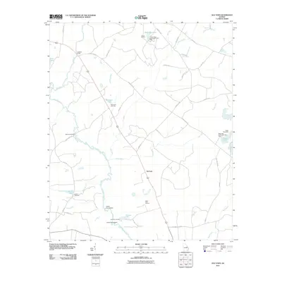
2011 Map of Old Town
USGS Topo · Published 2011About this map
The Ogeechee River meanders through this landscape, defining a rural corridor marked by agricultural fields and managed timberlands. The settlement of Old Town sits at a central crossroads, while the river's path is punctuated by distinctive bends known as the Upper Roundabout and Lower Roundabout. This geography of water management is evident in the numerous small reservoirs and family-named dams, such as Hancock Lake Dam and Wommack Lake Dam, which dot the drainages of Dry Creek and Spring Creek.
Find a feature on this map
44 named features on this map. Tap any name to fly to it.
Don’t see what you’re looking for? This feature index may not catch every label — zoom into the map to look around manually.
Map Details
Editions of this 2011 Old Town Map
This is the sole edition of this map. No revisions or reprints were ever made.
Other maps of this area

1919 · Gough
USGS Topo · 1:62,500

1920 · Stapleton
USGS Topo · 1:62,500

1948 · Stapleton
USGS Topo · 1:62,500

1948 · Gough
USGS Topo · 1:62,500

1948 · Louisville
USGS Topo · 1:24,000

1950 · Louisville
USGS Topo · 1:24,000
1950 · Gough
USGS Topo · 1:24,000

1950 · Kellys Pond
USGS Topo · 1:24,000

1953 · Athens
USGS Topo · 1:250,000

1957 · Macon
USGS Topo · 1:250,000