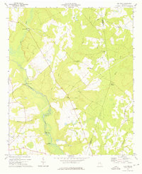
1973 Map of Old Town
USGS Topo · Published 1976About this map
The Ogeechee River meanders through this section of eastern Georgia, defined by its complex wetlands and distinctive river features such as the Upper Roundabout and Lower Roundabout. This 1973 survey captures the rural character of the Jefferson and Burke county line, where small settlements like Old Town and Street Place were anchored by a dense network of country churches. Local landmarks such as Mt Olive Ch, Union Bethel Ch, and San Clair Ch suggest the importance of these sites as community centers during the mid-20th century.
Find a feature on this map
30 named features on this map. Tap any name to fly to it.
Don’t see what you’re looking for? This feature index may not catch every label — zoom into the map to look around manually.
Map Details
Editions of this 1973 Old Town Map
This is the sole edition of this map. No revisions or reprints were ever made.
Other maps of this area

1919 · Gough
USGS Topo · 1:62,500

1920 · Stapleton
USGS Topo · 1:62,500

1948 · Stapleton
USGS Topo · 1:62,500

1948 · Gough
USGS Topo · 1:62,500

1948 · Louisville
USGS Topo · 1:24,000

1950 · Louisville
USGS Topo · 1:24,000
1950 · Gough
USGS Topo · 1:24,000

1950 · Kellys Pond
USGS Topo · 1:24,000

1953 · Athens
USGS Topo · 1:250,000

1957 · Macon
USGS Topo · 1:250,000