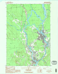
1988 Map of Old Town
USGS Topo · Published 1988About this map
The Penobscot River and Stillwater River define the complex geography of this central Maine region, where the primary settlements of Old Town and Orono are separated by the significant expanse of Marsh Island. In the late 20th century, the Univ of Maine campus dominates the southern portion of the island, while the industrial centers of Great Works and Milford line the banks of the Penobscot. The map reveals the intricate network of islands within the river system, including Orson Island and Indian Island, which sit amidst the braided channels. To the west, the massive Caribou Bog stretches toward the horizon, contrasting with the active urban and academic developments along the riverfront. Aviation and transport are represented by Dewitt Field, while smaller pockets of settlement like Pea Cove and French Settlement suggest the historical expansion of local communities beyond the riverbanks.
Find a feature on this map
51 named features on this map. Tap any name to fly to it.
Don’t see what you’re looking for? This feature index may not catch every label — zoom into the map to look around manually.
Map Details
Editions of this 1988 Old Town Map
2 editions found
Other maps of this area

1902 · Orono
USGS Topo · 1:62,500

1902 · Bangor
USGS Topo · 1:62,500

1917 · Passadumkeag
USGS Topo · 1:62,500

1933 · Boyd Lake
USGS Topo · 1:62,500

1942 · Bangor
USGS Topo · 1:62,500

1944 · Orono
USGS Topo · 1:62,500

1946 · Bangor
USGS Topo · 1:62,500

1946 · Orono
USGS Topo · 1:62,500

1948 · Bangor
USGS Topo · 1:250,000

1951 · Boyd Lake
USGS Topo · 1:50,000