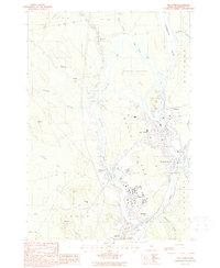
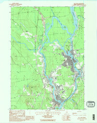
1988 Map of Old Town
USGS Topo · Published 1988About this map
The Penobscot River and Stillwater River define the industrial and academic character of this riverine corridor during the late 1980s. The landscape is dominated by complex water systems, where the main river splits to create Orson Island, Marsh Island, and Indian Island. The twin population centers of Old Town and Milford sit across from each other, while the southern reaches of Marsh Island are dominated by the extensive campus of the Univ of Maine at Orono.
Find a feature on this map
44 named features on this map. Tap any name to fly to it.
Don’t see what you’re looking for? This feature index may not catch every label — zoom into the map to look around manually.
Map Details
Editions of this 1988 Old Town Map
2 editions found
Other maps of this area

1902 · Orono
USGS Topo · 1:62,500

1902 · Bangor
USGS Topo · 1:62,500

1917 · Passadumkeag
USGS Topo · 1:62,500

1933 · Boyd Lake
USGS Topo · 1:62,500

1942 · Bangor
USGS Topo · 1:62,500

1944 · Orono
USGS Topo · 1:62,500

1946 · Bangor
USGS Topo · 1:62,500

1946 · Orono
USGS Topo · 1:62,500

1948 · Bangor
USGS Topo · 1:250,000

1951 · Boyd Lake
USGS Topo · 1:50,000