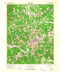
1962 Map of Olive Hill
USGS Topo · Published 1964About this map
Olive Hill serves as the central hub of this 1962 topographic landscape, situated where the Chesapeake and Ohio railroad follows the winding course of Tygarts Creek. The map documents a period of industrial activity in eastern Kentucky, showing numerous quarries and a claypit scattered among the ridges, alongside an oil well and a large pipeline cutting across the terrain. Small communities and named crossroads like Globe, Lawton, and Silica are linked by the rail line and rural roads.
Find a feature on this map
42 named features on this map. Tap any name to fly to it.
Don’t see what you’re looking for? This feature index may not catch every label — zoom into the map to look around manually.
Map Details
Editions of this 1962 Olive Hill Map
This is the sole edition of this map. No revisions or reprints were ever made.
Other maps of this area

1929 · Morehead
USGS Topo · 1:48,000

1935 · Morehead
USGS Topo · 1:62,500

1950 · Head Of Grassy
USGS Topo · 1:24,000

1950 · Bruin
USGS Topo · 1:24,000

1950 · Grahn
USGS Topo · 1:24,000

1950 · Wesleyville
USGS Topo · 1:24,000

1950 · Olive Hill
USGS Topo · 1:24,000

1950 · Ault
USGS Topo · 1:24,000

1950 · Tygarts Valley
USGS Topo · 1:24,000

1951 · Soldier
USGS Topo · 1:24,000