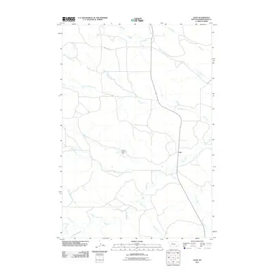
2011 Map of Olive
USGS Topo · Published 2011About this map
Olive occupies a central position in this corner of Powder River County, where the high plains are defined by an intricate network of drainage systems. The landscape is dominated by the long course of Mizpah Creek, which is joined by numerous tributaries including Ash Creek, Wolf Creek, and Road Creek. This 2011 survey illustrates the sparse, ranch-oriented settlement patterns of southeastern Montana, where infrastructure is largely limited to primary routes like Camp Creek Rd and Mizpah Rd. A notable point of human alteration in this natural watershed is the C Smith Number 1 Dam located along T Creek, serving as a vital water management feature for the surrounding arid lands. The map details the convergence of various forks, such as the North Fork Ash Creek and South Fork Ash Creek, which carve out the subtle topography of the region.
Find a feature on this map
18 named features on this map. Tap any name to fly to it.
Don’t see what you’re looking for? This feature index may not catch every label — zoom into the map to look around manually.
Map Details
Editions of this 2011 Olive Map
This is the sole edition of this map. No revisions or reprints were ever made.
Other maps of this area

1954 · Ekalaka
USGS Topo · 1:250,000

1956 · Ekalaka
USGS Topo · 1:250,000

1958 · Ekalaka
USGS Topo · 1:250,000

1965 · Ekalaka
USGS Topo · 1:250,000

1973 · Olive
USGS Topo · 1:24,000

1973 · Moonlight Creek
USGS Topo · 1:24,000

1973 · Box Elder Creek
USGS Topo · 1:24,000

1973 · Coalwood
USGS Topo · 1:24,000
1973 · Leslie Creek
USGS Topo · 1:24,000
1973 · Broadus
USGS Topo · 1:24,000