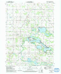
1992 Map of Oliver Lake
USGS Topo · Published 1993About this map
Oliver Lake and its neighboring basins form the centerpiece of this Northeastern Indiana landscape, where glacial geology and rural settlement patterns are clearly defined. The area is characterized by a dense network of water bodies, including Olin Lake, Dallas Lake, and Witmer Lake, many of which are linked by the Elkhart River system. This hydrologic profile is complemented by a heavy concentration of small, local institutions that speak to the region's agricultural history, such as the Meadow Lane School and Country Side School.
Find a feature on this map
70 named features on this map. Tap any name to fly to it.
Don’t see what you’re looking for? This feature index may not catch every label — zoom into the map to look around manually.
Map Details
Editions of this 1992 Oliver Lake Map
This is the sole edition of this map. No revisions or reprints were ever made.
Other maps of this area

1947 · Mongo
USGS Topo · 1:24,000

1947 · Lagrange
USGS Topo · 1:24,000

1947 · Wolcottville
USGS Topo · 1:24,000

1947 · Oliver Lake
USGS Topo · 1:24,000

1953 · Fort Wayne
USGS Topo · 1:250,000

1955 · Kendallville
USGS Topo · 1:24,000

1956 · Fort Wayne
USGS Topo · 1:250,000

1956 · Ligonier
USGS Topo · 1:24,000

1956 · Albion
USGS Topo · 1:24,000

1959 · Wolcottville
USGS Topo · 1:24,000