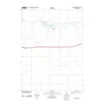
2011 Map of Oliver Reservoir
USGS Topo · Published 2011About this map
Oliver Reservoir serves as the central geographic feature of this high-plains landscape in Kimball County. Fed by Lodgepole Creek, the reservoir is managed by the Kimball Irrigation District Dam, illustrating the critical role of water management and irrigation in western Nebraska. The small settlement of Oliver and the nearby Oliver Reservoir Camping Area anchor the local geography, while the Kimball Canal extends eastward, diverting water for agricultural use. To the northwest, the Bushnell Cemetery provides a point of genealogical interest. The map also delineates the modern transportation corridor, including the Kimball Rest Area along the interstate, which parallels the older routes defined by the county road grid and the natural path of the creek.
Find a feature on this map
18 named features on this map. Tap any name to fly to it.
Don’t see what you’re looking for? This feature index may not catch every label — zoom into the map to look around manually.
Map Details
Editions of this 2011 Oliver Reservoir Map
This is the sole edition of this map. No revisions or reprints were ever made.
Other maps of this area

1954 · Scottsbluff
USGS Topo · 1:250,000

1958 · Scottsbluff
USGS Topo · 1:250,000
1972 · Bushnell SW
USGS Topo · 1:24,000

1972 · Kimball SW
USGS Topo · 1:24,000

1972 · Bushnell
USGS Topo · 1:24,000

1972 · Kimball
USGS Topo · 1:24,000

1972 · Bushnell SE
USGS Topo · 1:24,000

1972 · Oliver Reservoir
USGS Topo · 1:24,000

1973 · Kimball 2 SE
USGS Topo · 1:24,000
1973 · Kimball 2 SW
USGS Topo · 1:24,000