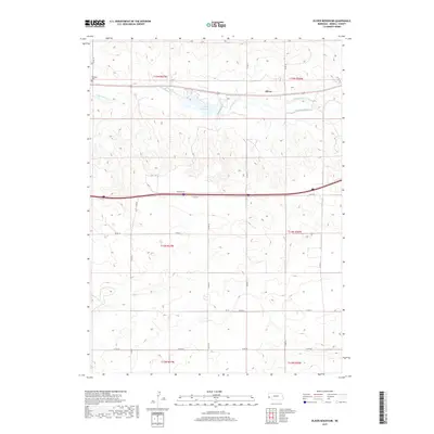
2017 Map of Oliver Reservoir
USGS Topo · Published 2017About this map
Oliver Reservoir serves as a central hydrological feature in this Kimball County landscape, catching the flow of Lodgepole Cr as it winds eastward. Near its banks, the settlement of Oliver and the waters of the Kimball Canal illustrate the essential relationship between water management and habitation in this high plains environment. The map details a strictly organized grid of rural corridors, including Forsling Rd and numerous county roads like Co RD 28, which define the property boundaries across various townships. In the northwestern corner, the Bushnell Cem stands as a quiet genealogical marker for the surrounding community. This modern survey reflects the enduring structure of the Public Land Survey System, showing how the original township and range divisions continue to dictate the placement of local infrastructure and agricultural tracks in western Nebraska.
Find a feature on this map
26 named features on this map. Tap any name to fly to it.
Don’t see what you’re looking for? This feature index may not catch every label — zoom into the map to look around manually.
Map Details
Editions of this 2017 Oliver Reservoir Map
This is the sole edition of this map. No revisions or reprints were ever made.
Other maps of this area

1954 · Scottsbluff
USGS Topo · 1:250,000

1958 · Scottsbluff
USGS Topo · 1:250,000
1972 · Bushnell SW
USGS Topo · 1:24,000

1972 · Kimball SW
USGS Topo · 1:24,000

1972 · Bushnell
USGS Topo · 1:24,000

1972 · Kimball
USGS Topo · 1:24,000

1972 · Bushnell SE
USGS Topo · 1:24,000

1972 · Oliver Reservoir
USGS Topo · 1:24,000

1973 · Kimball 2 SE
USGS Topo · 1:24,000
1973 · Kimball 2 SW
USGS Topo · 1:24,000