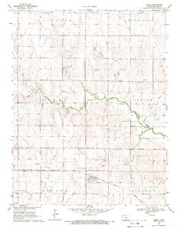
1969 Map of Olmitz
USGS Topo · Published 1971About this map
The town of Olmitz anchors this survey of central Kansas, situated along the Missouri Pacific railroad line. The landscape reflects a dual economy of agriculture and energy, with vast oil production areas including the Mater Oil Field, Mary A Oil Field, and Albion Oil Field spanning several townships. The drainage of Blood Creek and Landon Creek carves a winding path through the prairie terrain, which is divided into the administrative districts of Fairview, Wheatland, Grant, Walnut, and Eureka. Local history and genealogy are well-represented by several religious and community burial sites, notably St Anns Cem, Boyle Cem, and St Anthony Cem. This 1969 field-checked survey provides a meticulous record of rural infrastructure, from the prominent Radio Tower to the extensive underground Pipeline network that connects the various oil fields.
Find a feature on this map
20 named features on this map. Tap any name to fly to it.
Don’t see what you’re looking for? This feature index may not catch every label — zoom into the map to look around manually.
Map Details
Editions of this 1969 Olmitz Map
This is the sole edition of this map. No revisions or reprints were ever made.
Other maps of this area

1889 · Larned
USGS Topo · 1:125,000

1891 · Great Bend
USGS Topo · 1:125,000

1891 · Larned
USGS Topo · 1:125,000

1893 · Great Bend
USGS Topo · 1:125,000

1896 · Russell
USGS Topo · 1:125,000

1896 · Hays
USGS Topo · 1:125,000

1955 · Great Bend
USGS Topo · 1:250,000

1957 · Great Bend
USGS Topo · 1:250,000

1958 · Great Bend
USGS Topo · 1:250,000

1959 · Great Bend NE
USGS Topo · 1:24,000