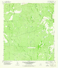
1974 Map of Olmos Creek
USGS Topo · Published 1977About this map
Kennedy Flats and the elevated terrain of Black Brush Ridge define this South Texas landscape where the borders of Zavala, Uvalde, Maverick, and Kinney counties converge. This 1974 survey illustrates a region dominated by intermittent water management, featuring an extensive network of drainage basins and named tanks such as Lilly Pad Tank and Government Tank. These water sources were vital for ranching operations in the brush country, where ephemeral streams like Olmos Gato Creek and Chaparrosa Creek only flow during significant rainfall.
Find a feature on this map
38 named features on this map. Tap any name to fly to it.
Don’t see what you’re looking for? This feature index may not catch every label — zoom into the map to look around manually.
Map Details
Editions of this 1974 Olmos Creek Map
This is the sole edition of this map. No revisions or reprints were ever made.
Other maps of this area

1896 · Brackett
USGS Topo · 1:125,000

1897 · Brackett
USGS Topo · 1:125,000

1898 · Uvalde
USGS Topo · 1:125,000

1899 · Uvalde
USGS Topo · 1:125,000

1939 · La Pryor
USGS Topo · 1:62,500

1940 · Chacon Creek
USGS Topo · 1:62,500

1949 · Cline
USGS Topo · 1:62,500

1953 · Crystal City
USGS Topo · 1:250,000

1954 · San Antonio
USGS Topo · 1:250,000

1955 · Crystal City
USGS Topo · 1:250,000