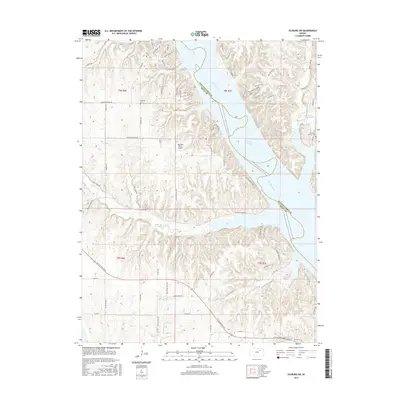
2015 Map of Olsburg SW
USGS Topo · Published 2015About this map
Tuttle Cr Lake dominates the center of this landscape, its expansive waters filling the valley of the Big Blue River. Along the western shores, residential and recreational developments like Golden Shores Dr and the Sunshine Ranch Airport suggest the area's modern identity as a destination for outdoor activity and lakeside living. The surrounding hills are deeply dissected by numerous tributaries, including Mill Creek and Kitten Cr, which carve into the rolling terrain of the Kansas landscape near the border of Pottawatomie and Riley Counties.
Find a feature on this map
73 named features on this map. Tap any name to fly to it.
Don’t see what you’re looking for? This feature index may not catch every label — zoom into the map to look around manually.
Map Details
Editions of this 2015 Olsburg SW Map
This is the sole edition of this map. No revisions or reprints were ever made.
Other maps of this area

1886 · Junction City
USGS Topo · 1:125,000

1889 · Junction City
USGS Topo · 1:125,000

1894 · Junction City
USGS Topo · 1:125,000

1947 · Manhattan
USGS Topo · 1:62,500

1947 · Fort Riley
USGS Topo · 1:62,500

1950 · Keats
USGS Topo · 1:24,000

1950 · Manhattan
USGS Topo · 1:24,000

1951 · Wind Creek
USGS Topo · 1:24,000

1955 · Fort Riley NE
USGS Topo · 1:24,000
1955 · Manhattan
USGS Topo · 1:24,000