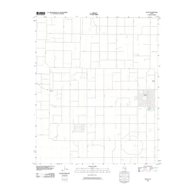
2010 Map of Olton
USGS Topo · Published 2010About this map
Olton serves as the primary hub of this High Plains landscape, characterized by a rigid, mile-by-mile grid of country roads and irrigation patterns. The map highlights the localized nature of West Texas aviation at Del-Tex Airport, situated just northeast of the main settlement. Further west, the small community of Circle sits at a crossroads, representing the dispersed nature of agricultural service points in Lamb County. The region's transport network is defined by state-maintained routes like FM 168, FM 1842, and FM 1072, which stitch together an area dominated by large-scale farming and numerous unnamed depressions or playas typical of the Llano Estacado. This 2010 edition documents the contemporary footprint of the town and its surrounding rural infrastructure.
Find a feature on this map
30 named features on this map. Tap any name to fly to it.
Don’t see what you’re looking for? This feature index may not catch every label — zoom into the map to look around manually.
Map Details
Editions of this 2010 Olton Map
This is the sole edition of this map. No revisions or reprints were ever made.
Other maps of this area

1954 · Clovis
USGS Topo · 1:250,000

1958 · Clovis
USGS Topo · 1:250,000

1962 · Cofferville
USGS Topo · 1:24,000

1962 · Springlake
USGS Topo · 1:24,000

1962 · Fieldton
USGS Topo · 1:24,000

1963 · Olton
USGS Topo · 1:24,000

1963 · Dodd SE
USGS Topo · 1:24,000

1963 · Hart SW
USGS Topo · 1:24,000

1965 · Hilburn
USGS Topo · 1:24,000
1968 · Corry
USGS Topo · 1:24,000