
1962 Map of Springlake
USGS Topo · Published 1965About this map
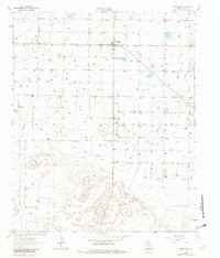
Springlake is the central hub of this 1962 landscape in Lamb County, surrounded by a high density of wells that speak to the intense agricultural irrigation of the Texas Panhandle. The map reveals a structured rural community at mid-century, anchored by the Community Hall and the nearby Springlake School 0.6 Mi.. The terrain is remarkably level, punctuated only by shallow depressions and an extensive network of irrigation infrastructure. This survey captures a specific moment in the region's development, characterized by a grid of property boundaries and a significant industrial presence marked by a prominent Pipeline traversing the territory. The abundance of labeled wells across the sheet illustrates the critical role of groundwater management during this era of Texas water history.
Find a feature on this map
5 named features on this map. Tap any name to fly to it.
Don’t see what you’re looking for? This feature index may not catch every label — zoom into the map to look around manually.
Map Details
Editions of this 1962 Springlake Map
2 editions found
Other maps of this area

1954 · Clovis
USGS Topo · 1:250,000

1958 · Clovis
USGS Topo · 1:250,000

1962 · Amherst
USGS Topo · 1:24,000

1962 · Cofferville
USGS Topo · 1:24,000

1962 · Fieldton
USGS Topo · 1:24,000

1963 · Earth
USGS Topo · 1:24,000

1963 · Olton
USGS Topo · 1:24,000

1963 · Dodd SE
USGS Topo · 1:24,000

1963 · Dodd
USGS Topo · 1:24,000

1963 · Hart SW
USGS Topo · 1:24,000