
1963 Map of Earth
USGS Topo · Published 1965About this map
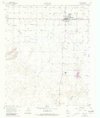
Earth serves as the primary hub on this High Plains landscape, situated just north of the meandering course of Blackwater Draw. The settlement pattern reflects the mid-century agricultural and industrial development of Lamb County, with a network of unimproved roads and a Jeep Trail cutting through the terrain. Evidence of the era's local economy is visible in the scattered Gravel Pit and Sandpits operations, along with a Power Plant X located further south. Cultural landmarks such as the Drive-in Theater and Memorial Cem provide a look into the community life of the early 1960s. To the west, the Halsell Ranch and the waters of Spring Lake anchor the more rural sections of the survey, while a prominent Pipeline and sewage disposal facilities mark the expanding infrastructure serving the Texas Panhandle.
Find a feature on this map
13 named features on this map. Tap any name to fly to it.
Don’t see what you’re looking for? This feature index may not catch every label — zoom into the map to look around manually.
Map Details
Editions of this 1963 Earth Map
2 editions found
Other maps of this area

1954 · Clovis
USGS Topo · 1:250,000

1958 · Clovis
USGS Topo · 1:250,000

1962 · Amherst
USGS Topo · 1:24,000

1962 · Sudan
USGS Topo · 1:24,000

1962 · Muleshoe NE
USGS Topo · 1:24,000

1962 · Cofferville
USGS Topo · 1:24,000

1962 · Springlake
USGS Topo · 1:24,000

1963 · Dodd SE
USGS Topo · 1:24,000

1963 · Dodd
USGS Topo · 1:24,000
1963 · Lazbuddie SE
USGS Topo · 1:24,000