
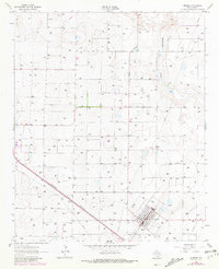
1962 Map of Amherst
USGS Topo · Published 1965About this map
The agricultural landscape of Amherst is defined by a dense grid of irrigation wells and the diagonal path of the Panhandle and Santa Fe railroad in the early 1960s. This High Plains terrain is marked by numerous depressions and the winding course of Blackwater Draw, which cuts through the northeastern corner of the map. The town site itself shows an organized residential layout centered around the High Sch, while utility infrastructure like a Radio Tower and Substation point to the area's mid-century modernization. Smaller settlements like Bailey and various unnamed ranch complexes are connected by an extensive network of local roads and an industrial Pipeline, reflecting the region's heavy reliance on groundwater management and rail transportation for its farming economy.
Find a feature on this map
10 named features on this map. Tap any name to fly to it.
Don’t see what you’re looking for? This feature index may not catch every label — zoom into the map to look around manually.
Map Details
Editions of this 1962 Amherst Map
2 editions found
Other maps of this area

1954 · Clovis
USGS Topo · 1:250,000

1954 · Brownfield
USGS Topo · 1:250,000

1958 · Brownfield
USGS Topo · 1:250,000

1958 · Clovis
USGS Topo · 1:250,000

1962 · Brownfield
USGS Topo · 1:250,000

1962 · Sudan
USGS Topo · 1:24,000

1962 · Muleshoe NE
USGS Topo · 1:24,000

1962 · Cofferville
USGS Topo · 1:24,000

1962 · Springlake
USGS Topo · 1:24,000

1963 · Earth
USGS Topo · 1:24,000