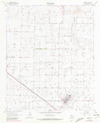
1962 Map of Amherst
USGS Topo · Published 1981About this map
The small plains settlement of Amherst is the primary focus of this high-plains landscape, situated along the Panhandle and Santa Fe railroad line. The map highlights the town's local civic infrastructure during the early 1960s, featuring the High Sch, a Substation, and a Radio Tower that served the community. Outside the town limits, the terrain is characterized by a sparse network of section lines and isolated Well sites, indicating the critical role of water management in this semi-arid region of the Texas Panhandle.
Find a feature on this map
9 named features on this map. Tap any name to fly to it.
Don’t see what you’re looking for? This feature index may not catch every label — zoom into the map to look around manually.
Map Details
Editions of this 1962 Amherst Map
2 editions found
Other maps of this area

1954 · Clovis
USGS Topo · 1:250,000

1954 · Brownfield
USGS Topo · 1:250,000

1958 · Brownfield
USGS Topo · 1:250,000

1958 · Clovis
USGS Topo · 1:250,000

1962 · Brownfield
USGS Topo · 1:250,000

1962 · Amherst
USGS Topo · 1:24,000

1962 · Sudan
USGS Topo · 1:24,000

1962 · Muleshoe NE
USGS Topo · 1:24,000

1962 · Cofferville
USGS Topo · 1:24,000

1962 · Springlake
USGS Topo · 1:24,000