
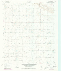
1963 Map of Dodd
USGS Topo · Published 1965About this map
Agricultural development across the Llano Estacado defines this area of West Texas during the early 1960s. The small settlement of Dodd sits near the crossing of local routes, providing a central point for the surrounding farmsteads straddling the border between Castro Co and Lamb Co. The landscape is characterized by a high density of irrigation infrastructure, with scores of numbered wells like Well 3817 and Well 3787 supporting the intensive cultivation of the high plains. Natural drainage is limited to the winding path of Running Water Draw in the northeastern corner, which cuts through the otherwise uniform topography. Local community life is anchored by landmarks such as the Primitive Ch, while the map's fine red dashed lines delineate the extensive system of property fences that organized this productive rural territory.
Find a feature on this map
85 named features on this map. Tap any name to fly to it.
Don’t see what you’re looking for? This feature index may not catch every label — zoom into the map to look around manually.
Map Details
Editions of this 1963 Dodd Map
2 editions found
Other maps of this area

1954 · Clovis
USGS Topo · 1:250,000

1958 · Clovis
USGS Topo · 1:250,000

1962 · Muleshoe NE
USGS Topo · 1:24,000

1962 · Dodd NE
USGS Topo · 1:24,000

1962 · Springlake
USGS Topo · 1:24,000

1963 · Flagg
USGS Topo · 1:24,000

1963 · Earth
USGS Topo · 1:24,000

1963 · Lazbuddie
USGS Topo · 1:24,000

1963 · Dodd SE
USGS Topo · 1:24,000
1963 · Lazbuddie SE
USGS Topo · 1:24,000