
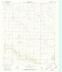
1963 Map of Flagg
USGS Topo · Published 1965About this map
Running Water Draw and its North Fork Running Water Draw meander through this Castro County landscape, defining the topography of the High Plains. This 1960s study, supported by the Texas Water Commission and the High Plains Underground Water Conservation District No. 1, reveals a high density of water infrastructure across the plains. Dozens of identified wells, including Well 3888 and Well 3814, indicate a heavy reliance on the Ogallala Aquifer for regional agriculture and settlement. The small community of Flagg and the location of Big Square serve as the primary human landmarks in an area otherwise characterized by vast stretches of irrigated land and intermittent drainage patterns. The map provides a precise look at the rural intersection of hydrology and habitation in West Texas during a period of significant agricultural development.
Find a feature on this map
68 named features on this map. Tap any name to fly to it.
Don’t see what you’re looking for? This feature index may not catch every label — zoom into the map to look around manually.
Map Details
Editions of this 1963 Flagg Map
2 editions found
Other maps of this area

1954 · Clovis
USGS Topo · 1:250,000

1958 · Clovis
USGS Topo · 1:250,000

1962 · Dodd NE
USGS Topo · 1:24,000

1963 · Lazbuddie
USGS Topo · 1:24,000

1963 · Dodd SE
USGS Topo · 1:24,000

1963 · Dodd
USGS Topo · 1:24,000
1963 · Lazbuddie SE
USGS Topo · 1:24,000

1965 · Dimmitt
USGS Topo · 1:24,000

1965 · Dimmitt SW
USGS Topo · 1:24,000

1965 · Tam Anne
USGS Topo · 1:24,000