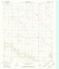
1963 Map of Flagg
USGS Topo · Published 1981About this map
Intermittent drainage patterns and deep-well irrigation define this portion of the Texas Panhandle. The High Plains landscape is dominated by the North Fork Running Water Draw and Running Water Draw, which carve shallow depressions across the terrain. These ephemeral waterways are surrounded by hundreds of individual water wells, reflecting the intensive agricultural development of the 1960s and 1970s. The settlement of Flagg and the crossroads at Big Square serve as central points for the surrounding rural homesteads and industrial farming operations, which include a large Feedlot and a private Landing Strip. The map, updated with 1979 aerial photography, captures the evolution of local infrastructure, including an extensive network of ranch roads and section-line fences that organize the semi-arid plains into a productive agricultural grid.
Find a feature on this map
7 named features on this map. Tap any name to fly to it.
Don’t see what you’re looking for? This feature index may not catch every label — zoom into the map to look around manually.
Map Details
Editions of this 1963 Flagg Map
2 editions found
Other maps of this area

1954 · Clovis
USGS Topo · 1:250,000

1958 · Clovis
USGS Topo · 1:250,000

1962 · Dodd NE
USGS Topo · 1:24,000

1963 · Flagg
USGS Topo · 1:24,000

1963 · Lazbuddie
USGS Topo · 1:24,000

1963 · Dodd SE
USGS Topo · 1:24,000

1963 · Dodd
USGS Topo · 1:24,000
1963 · Lazbuddie SE
USGS Topo · 1:24,000

1965 · Dimmitt
USGS Topo · 1:24,000

1965 · Dimmitt SW
USGS Topo · 1:24,000