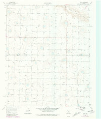
1963 Map of Dodd
USGS Topo · Published 1981About this map
The High Plains landscape of the Texas Panhandle is defined by a sparse, grid-dependent settlement pattern in this early 1960s study. The small community of Dodd serves as the primary focal point, situated along the county line where Castro Co Lamb Co meet. The terrain is characterized by an extensive network of water wells, reflecting the intense agricultural reliance on the Ogallala Aquifer during this era. A rare break in the flat topography occurs at Running Water Draw, which winds through the northeastern quadrant. Local social life and genealogy are anchored by the Primitive Ch, one of the few named structures outside of the central village. This map captures the region after the expansion of groundwater irrigation but before later shifts in regional land use, with fine fence lines and section boundaries clearly delineated across the plains.
Find a feature on this map
5 named features on this map. Tap any name to fly to it.
Don’t see what you’re looking for? This feature index may not catch every label — zoom into the map to look around manually.
Map Details
Editions of this 1963 Dodd Map
2 editions found
Other maps of this area

1954 · Clovis
USGS Topo · 1:250,000

1958 · Clovis
USGS Topo · 1:250,000

1962 · Muleshoe NE
USGS Topo · 1:24,000

1962 · Dodd NE
USGS Topo · 1:24,000

1962 · Springlake
USGS Topo · 1:24,000

1963 · Flagg
USGS Topo · 1:24,000

1963 · Earth
USGS Topo · 1:24,000

1963 · Lazbuddie
USGS Topo · 1:24,000

1963 · Dodd SE
USGS Topo · 1:24,000

1963 · Dodd
USGS Topo · 1:24,000