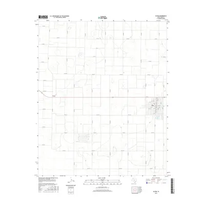
2016 Map of Olton
USGS Topo · Published 2016About this map
Olton serves as the primary settlement and commercial hub of this High Plains landscape, organized around a dense grid of residential and business streets including 1st St and 9th St. The town's layout reflects the agricultural order of Lamb County, where a rigid network of county roads like Co Rd 102 and Co Rd 299 divides the surrounding farmland into precise sections. West of the main township, the small community of Circle sits along the same east-west axis, illustrating the dispersed settlement patterns typical of this era. The map details a landscape where water management and transportation are paramount, evidenced by the numerous small depressions and the convergence of regional thoroughfares such as Fm 168 and Fm 2080. This survey offers a clear view of the rural infrastructure and street-level geography that defines the Llano Estacado region in the mid-2010s.
Find a feature on this map
57 named features on this map. Tap any name to fly to it.
Don’t see what you’re looking for? This feature index may not catch every label — zoom into the map to look around manually.
Map Details
Editions of this 2016 Olton Map
This is the sole edition of this map. No revisions or reprints were ever made.
Other maps of this area

1954 · Clovis
USGS Topo · 1:250,000

1958 · Clovis
USGS Topo · 1:250,000

1962 · Cofferville
USGS Topo · 1:24,000

1962 · Springlake
USGS Topo · 1:24,000

1962 · Fieldton
USGS Topo · 1:24,000

1963 · Olton
USGS Topo · 1:24,000

1963 · Dodd SE
USGS Topo · 1:24,000

1963 · Hart SW
USGS Topo · 1:24,000

1965 · Hilburn
USGS Topo · 1:24,000
1968 · Corry
USGS Topo · 1:24,000